


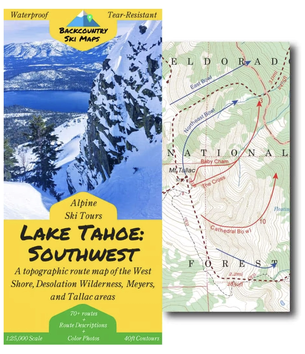
Lake Tahoe: Southwest —
With beautiful bowls, steep and deep couloirs, glorious glades, and electric-blue views, the Southwest corner of Lake Tahoe is a true backcountry skiing Mecca. Make the most of your ski days here by using this topographic route map to guide you to the best backcountry ski routes in the West Shore, Desolation Wilderness, and Meyers areas of the lake.
This comprehensive topographical route map makes it easy to find new ski lines in the Tahoe backcountry. Covering the area from Rubicon Peak down to Ralston Peak from North to South, and from Mt. Price to Flagpole Peak from East to West (see below above for a zoomable map with the full area of coverage), it includes some of the raddest descents around.
Route information, including suggested approaches and descents, is marked on a large scale 1:25,000 map to get you home safely. The map is accompanied on the back by a self-contained field-guide which shows photos and gives detailed descriptions of some of the most worthy descents – the perfect way to get in the know about backcountry skiing in Tahoe.
Descents of all varieties – from killer couloirs to wide open glades – are all covered, so there is something for everyone from the hardened veteran to the beginner tourer.
- 70 descents ranging from classics to rarely-skied lines.
- Suggested ascent routes to get you up the hill as efficiently as possible.
- Field-guide to the best descents complete with color photos.
- Waterproof, tear-resistant so you never have to worry about damaging your map.
- Fits in your pocket – the map folds down to 4.25″ x 9″ (21.25″ x 27″ when open).
- Highly detailed with 40ft contour lines.
- Easily readable with a 1:25,000 scale.
Includes ski routes on:
- Mt. Tallac
- Jake’s Peak
- Pyramid Peak
- Dick’s Peak
- Echo Peak
- Angora Peak
- and many more!
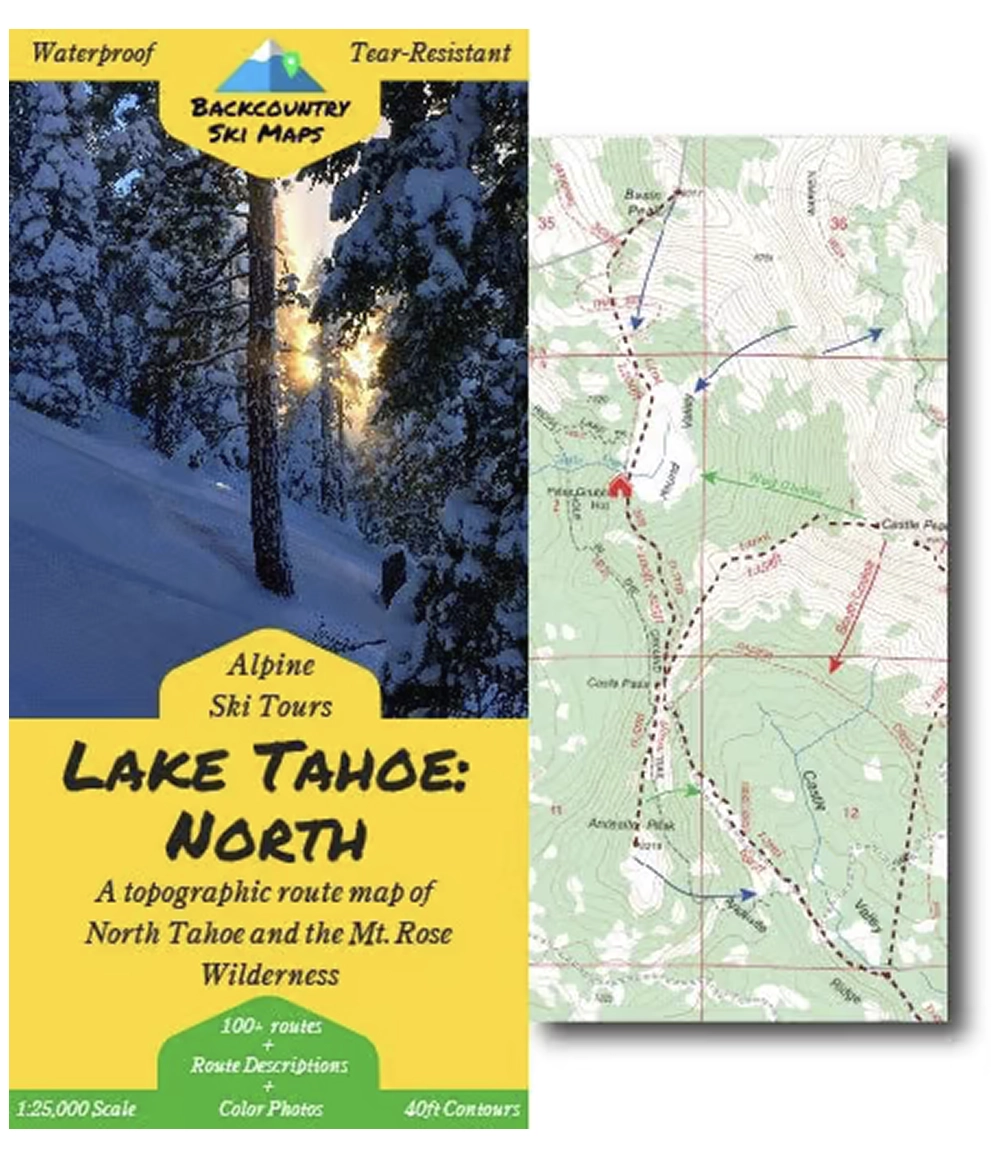
Lake Tahoe: North —
With abundant snowfall, sunny skies, and stunning views, Lake Tahoe is home to some of the world’s best backcountry skiing. Make the most of this gift with the second entry in our [Backcountry Ski Maps] Tahoe map series: Alpine Ski Tours – Lake Tahoe: North, a comprehensive topographic route map specifically designed to get you to the goods as effortlessly as possible.
If you want to make the most of a backcountry ski trip to Tahoe, this map will be your ultimate information source. The areas covered in the map include the Mount Rose Wilderness and the areas around Truckee from Castle Peak all the way down to the northern border of Squaw Valley (see zoomable map below for full area of coverage).
Route information, including suggested approaches and descents, is marked on a large scale 1:25,000 map, so it’s easy to stay on track. Like all Backcountry Ski Maps, the Lake Tahoe: North map is accompanied by a self-contained field-guide containing detailed descriptions and photos of some of the most worthy descents – so you can spend less time looking up information and more time skiing!
Descents of all varieties – from killer couloirs to wide open bowls to perfectly spaced glades – are all covered, so you can find your perfect line whether this is your first or your thousandth day in the Tahoe backcountry.
- More than 100 descents ranging from classics to rarely-skied lines.
- Suggested ascent routes to get you up the hill as efficiently as possible.
- Field-guide to the best descents complete with color photos.
- Waterproof, tear-resistant so you never have to worry about damaging your map.
- Fits in your pocket – the map folds down to 4.25″ x 9″.
- Highly detailed with 40ft contour lines.
- Easily readable with a 1:25,000 scale.
Includes ski routes on:
- Mt. Rose
- Castle Peak
- Tamarack Peak
- Relay Peak
- Donner Peak
- Silver Peak
- and many more!
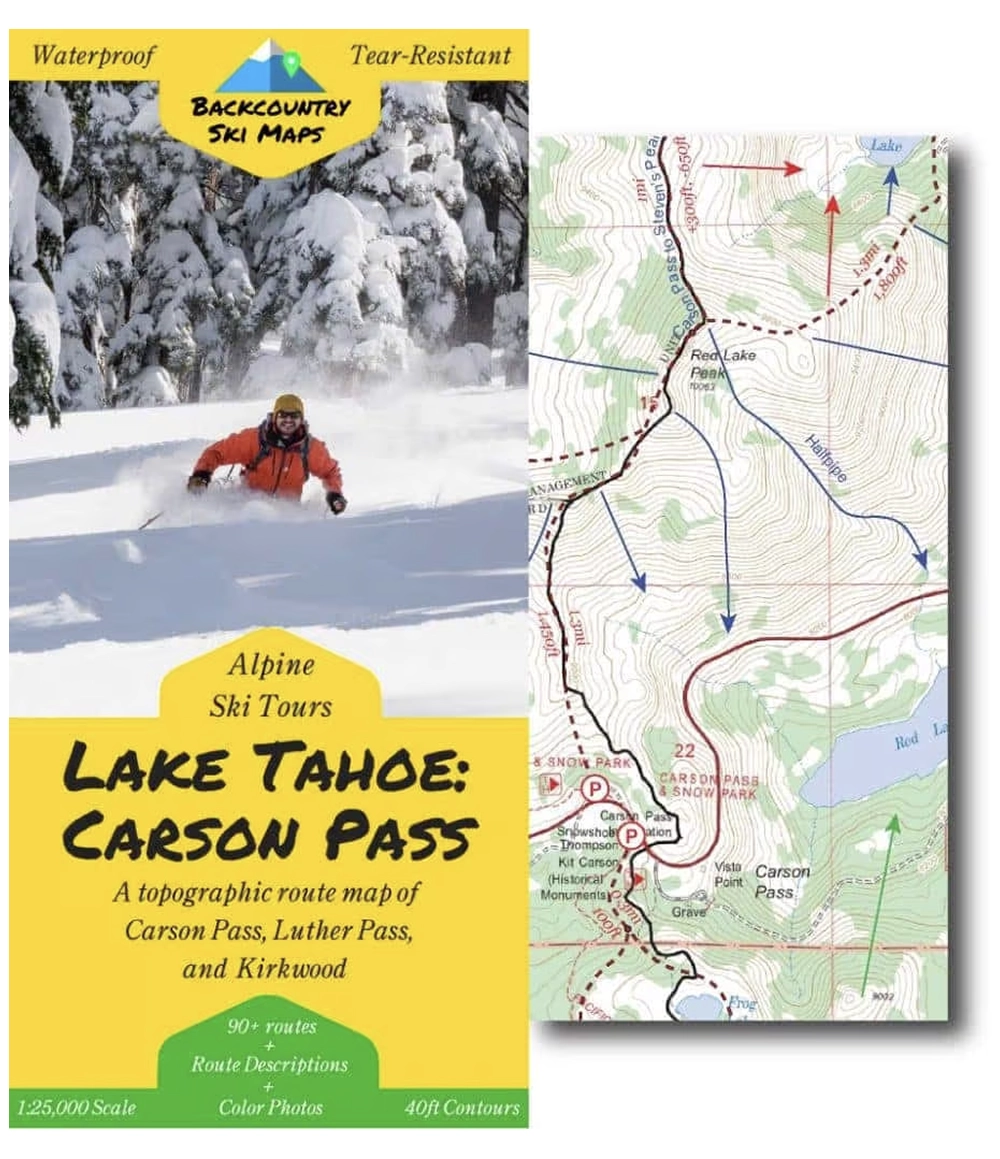
Lake Tahoe: Carson Pass —
If you’re looking to access the unbeatable high alpine terrain around Carson Pass, this topographic map route map is the place to start. The third map in our [Backcountry Ski Maps] Tahoe map series, this map covers this backcountry ski routes from Powderhouse down to Carson Pass and even the lift-accessed backcountry around Kirkwood included, there are enough world-class ski descents on here to keep even the most avid powderhound sated.
This easy-to-use map covers the Carson Pass area just South of Lake Tahoe, from Powderhouse Peak down to Round Top and Deadwood Peak, including the lift-accessed backcountry around Kirkwood (see below for a zoomable map with the full area of coverage).
Route information, including suggested approaches and descents, is marked on a large scale 1:25,000 map, to help you make the most out of every day in the Carson Pass backcountry. The map is accompanied on the back by a self-contained field-guide which shows photos and gives detailed descriptions of some of the most worthy descents, making it easy to find the best trips for any conditions.
Descents of all varieties – from killer couloirs to wide open glades – are all covered, so that you can find the run that’s right for you, whether you’re a a hardened veteran or a beginner tourer.
- 90 descents ranging from classics to rarely-skied lines.
- Suggested ascent routes to get you up the hill as efficiently as possible.
- Field-guide to the best descents complete with color photos.
- Waterproof, tear-resistant so you never have to worry about damaging your map.
- Fits in your pocket – the map folds down to 4.25″ x 9″.
- Highly detailed with 40ft contour lines.
- Easily readable with a 1:25,000 scale.
Includes ski routes on:
- Round Top
- Powderhouse Peak
- Waterhouse Peak
- Melissa Coray Peak
- Fourth of July Peak
- Steven’s Peak
- Deadwood Peak
- and many more!
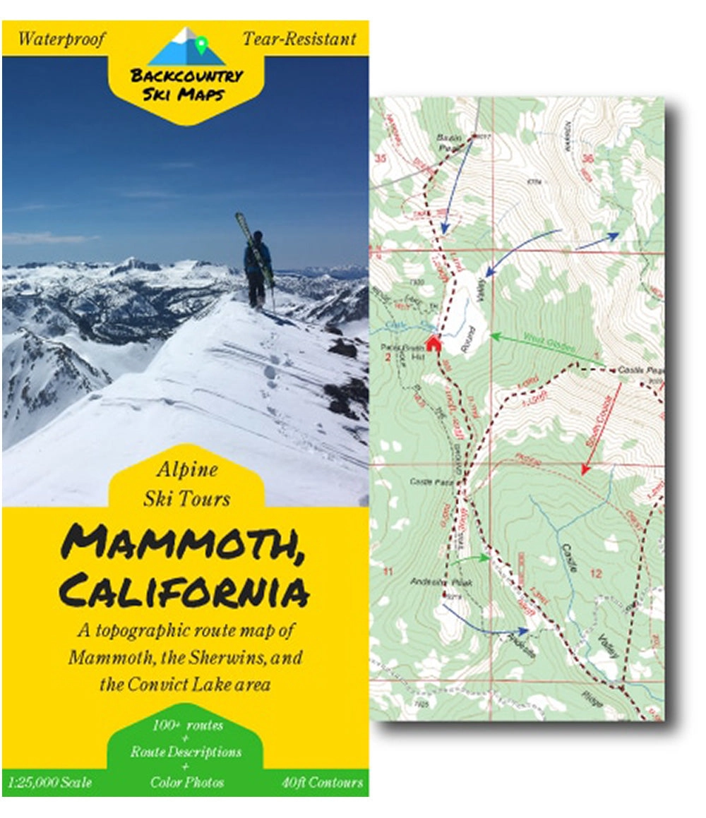
Mammoth, California —
If you’re looking to access the unbeatable high alpine terrain around Mammoth, this topographic map route map is the place to start. With backcountry ski routes from the glades of Punta Bardini to the steeps of the Bloody Couloir and Convict Lake, there are enough world-class ski descents on here to keep even the most avid powderhound sated.
This easy-to-use map covers the area around Mammoth Lakes, California, including the Sherwins, the Mammoth Crest, and the area around Convict Lake, including ski routes on:
- Punta Bardini
- The Sherwins
- Bloody Mountain
- Laurel Mountain
- Red Slate Mountain
- Mammoth Crest
- and many more!
Route information, including suggested approaches and descents, is marked on a large scale 1:25,000 map, to help you make the most out of every day in the Mammoth backcountry. The map is accompanied on the back by a self-contained field-guide which shows photos and gives detailed descriptions of some of the most worthy descents, making it easy to find the best trips for any conditions.
Descents of all varieties – from killer couloirs to wide open glades – are all covered, so that you can find the run that’s right for you, whether you’re a a hardened veteran or a beginner tourer.
- 100 descents ranging from classics to rarely-skied lines.
- Suggested ascent routes to get you up the hill as efficiently as possible.
- Field-guide to the best descents complete with color photos.
- Waterproof, tear-resistant so you never have to worry about damaging your map.
- Fits in your pocket – the map folds down to 4.25″ x 9″ (29.75″ x 25″ when unfolded).
- Highly detailed with 40ft contour lines.
- Easily readable with a 1:25,000 scale.


 - Gigabit Ethernet, iSCSI, 10 Gigabit Ethernet, 33698-M4217")


